|
|
 |
Wider Countryside Butterfly Survey - 2016
***LATEST NEWS***
New Squares added for 2016! Download the WCBS 2010 newsletter which provides a rundown of last years results and the fantastic news that the WCBS will continue for the next 3 years at least! Last year was a great success and we hope to improve take-up in the coming seasons!
Zoe Randle (National Co-ordinator) - April 2016
Would you like to help a butterfly survey scheme?
Can you spare time on 2 days in July and August to visit a grid square and do two 1km walks to record butterflies?
Then this is for you.
Between 2006 and 2008 a few Butterfly Conservation branches took part in a pilot scheme to test a method of sampling butterfly populations in the wider countryside. This method is intended to compliment, not replace transects, and enable records from a wide variety of habitats to be collected. The areas to be surveyed have been randomly picked by Butterfly Conservation headquarters to give a good spread in each branch area. Some squares will be rich in butterflies, others less so, but all results will be important.
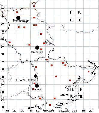
Where are we surveying?
The 1km squares selected at random by the national survey co-ordinator are:
1km Square |
Location |
2014 Volunteer found |
|
| CAMBRIDGESHIRE |
TL2693 |
Pondersbridge |
NEW | |
TF1504 |
Werrington, Petebrorough |
NEW | |
TL2177 |
nr Alconbury airfield |
NEW | |
TF1704 |
Werrington, Petebrorough |

| |
TL3843 |
Melbourn |
| |
TF2105 |
Newborough, NE of Peterborough |
| |
TL4498 |
Andrews Farm, 2 miles NE of March |
NO | |
TF4513 |
Wisbech |
NO | |
TL2486 |
Near Ramsey, 8 miles N of Huntingdon |
| |
TL3085 |
Just NE of Ramsey |
| |
TL4789 |
Manea, 5 miles NE of Chatteris |
| |
TL4989 |
Ouse Washes, 1 mile E of Manea |
| |
TL5373 |
Between Stretham & Soham |
| |
TL1166 |
Near Kimbolton, 5 miles NW of St. Neots |
NO | |
TL3962 |
Near Dry Drayton |
| |
TL5764 |
Just N of Swaffham Prior |
| |
TL5456 |
2 miles NE of Fulbourn |
NO | |
TL6142 |
Camps End |
| |
| ESSEX |
TL6415 |
Upper Harveys, south of Dunmow |
NEW | |
TL7714 |
Terling, nr Hatfield Peverel |
NEW | |
< TL8226 |
Buttons Green near Marks Hall |
| |
TL6226 |
North of Dunmow |
NO | |
TL4404 |
Epping Upland, near Harlow |
| |
TL4610 |
Mark Hall South area of Harlow |
NO | |
TL4833 |
1 mile NE of Clavering |
NO | |
TL6935 |
3 miles N of Finchingfield |
NO | |
TL7320 |
Great Notley, Braintree |
| |
TL8339 |
W of Bulmer, 3 miles SW of Sudbury |
| |
TL8536 |
Between Sudbury and Halstead |
| |
TL9315 |
Tolleshunt Knights, near Tiptree |
| |
TM1827 |
Great Oakley |
| |
TQ5390 |
Harold Wood, Romford |
| |
TQ6682 |
Horndon on the Hill, Thurrock |
| |
TQ7091 |
N side of Basildon |
| |
|